Google SWE points 48 AI agents at NASA Lidar, finds unmapped Maya pyramid in 72h
- Source
- pietromiotti.com
- Author
- eyvindn
- Date
Context
A self-described non-archaeologist used general-purpose AI agents to search public lidar scans of the Maya region, and Mexico's national heritage agency confirmed that the site they flagged is not in its register. That is what the post on pietromiotti.com establishes: the location is unregistered, not that it is a verified Maya site. The author acknowledges this, though the post's own headline says the agents found a Maya site: the post calls the find "not official yet" and says that, as far as anyone can tell, nobody had mapped it before. Lidar is what made the search possible. From a satellite, a ruin under jungle looks like more trees, but lidar fires laser pulses through gaps in the canopy and records the shape of the ground beneath.
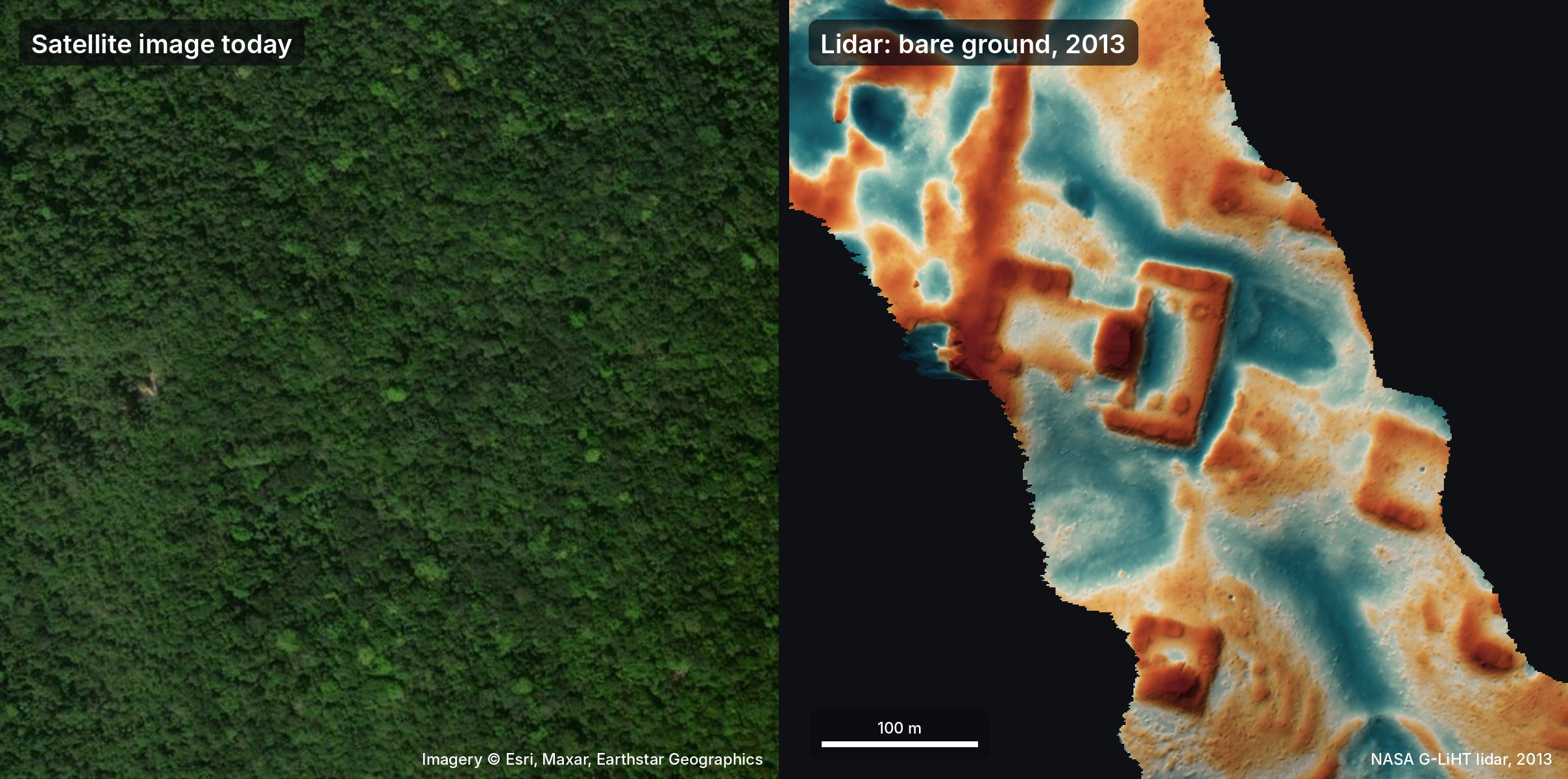
According to the author, the agents turned NASA lidar strips covering about 1,200 square kilometers of jungle into images, and 48 agents went through them one by one, following a written guide to look for pyramids, platforms and plazas while ruling out natural hills, sinkholes and roads. The author stresses that no specialized model or trained detector was involved: the agents looked at the pictures. The author then had them search the literature and archives for which of the flagged settlements had not been recorded, and they singled out one hilltop on the edge of a cliff with straight edges and sharp corners. In the lidar it shows a levelled plaza, an oval pyramid at least 8 to 12 meters tall, a raised courtyard and a flat-bottomed hollow. The agents also checked the raw lidar points to confirm the shapes lay on the ground rather than in the trees, and drafted a report that was translated into Spanish, a language the author says they do not speak.
The author sent the report to INAH, Mexico's National Institute of Anthropology and History, and less than 72 hours after the idea first came up it replied that it had found no registered archaeological site at that location. The author's reading of the site as a small Classic-period civic centre, with a temple pyramid, a ruler's courtyard and perhaps a rainwater reservoir, is, in the post's words, speculation from a long chat with the agents. Whether it is a Maya site now depends on fieldwork, which in Mexico needs INAH's authorization, and it is up to the local INAH centre to decide whether to send a team. Using lidar to find Maya settlements is not new; the post points to earlier studies, including one it describes as finding a whole Maya city in Mexico in 2024 (Auld-Thomas et al.). What this account adds is that the slow parts of a first pass, scanning the imagery, checking it against published records and preparing the report, were done by off-the-shelf agents working from instructions, leaving expert confirmation as the step that remains.


Checking sign-in…
Loading comments…