How Ai2 scaled Earth-observation inference to a continent in a day
- Source
- x.com
- Date

The organizations best positioned to use Earth-observation models – those working in conservation, food security, & disaster response – often can't run these models at the scale they need. That's an infrastructure problem. So we built the OlmoEarth Platform to solve it. 🧵
Context
Ai2 built the OlmoEarth Platform so that groups working on conservation, food security and disaster response can run its Earth-observation models over large areas, since such organizations often lack the infrastructure or engineering teams to manage the whole process themselves. These models read satellite imagery and produce maps. Ai2's engineering post, which Intel also carries on its own, explains that at this scale much of the work happens around the model. A job can pull terabytes of imagery from several providers with different projections and resolutions, has to cope with clouds and missing observations, and must keep every prediction aligned to one map grid. Fetching and preparing the imagery often takes longer than running the model.
The platform handles this by cutting a job into pieces that do not depend on each other. It divides the region into partitions sized for one worker machine, then into smaller windows matched to the model's input. Neighboring partitions overlap slightly, and the overlap is reconciled when the outputs are stitched together so the finished map has no seams. Each piece passes through three stages on hardware suited to the work: CPU machines fetch, reproject and normalize the imagery, GPU machines run the model, and CPU machines stitch and export the results. Instead of querying providers' public catalogs at burst rates, Ai2 keeps its own index of where each satellite scene's pixels are stored, so workers read only the bytes their partition needs. Tasks are written so they can be safely rerun, which lets the system retry failures and restart stalled workers.
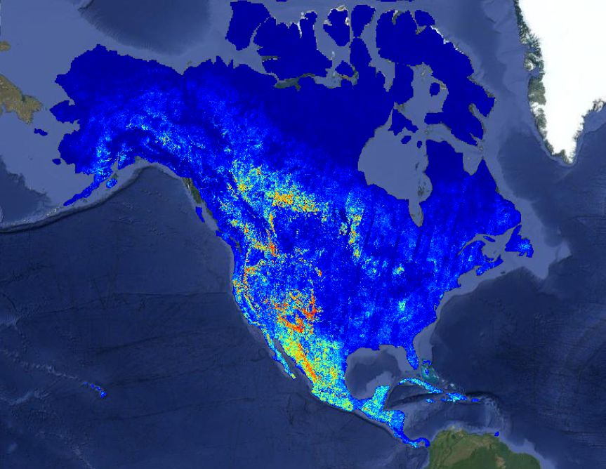
The headline result is a wildfire-risk map covering all of North America. Ai2 reports that the run took about 30.5 hours of wall-clock time, against an estimated 4,737 hours if the same computation had been done one piece after another, and calls this a 155-fold speedup. The gain comes from parallelism, with roughly 19,600 CPUs and 994 GPUs working at peak, not from a faster model. Ai2 says continent-scale runs take roughly a day at a cost of fractions of a penny per square kilometer, without giving exact costs, and the post does not report how accurate the wildfire map is.
- inference — Running a trained model to get answers — the phase where AI is actually used, as opposed to trained.



Checking sign-in…
Loading comments…